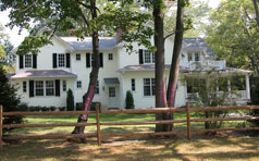
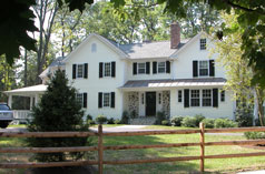
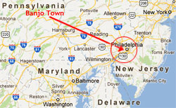
Banjo Town sits approx. 13 miles NW of Philadelphia, 1 mile south of Lancaster Pike & the PRR
Banjo Town is
a historic neighborhood founded in 1885, situated dead center of Radnor Township, Delaware County,
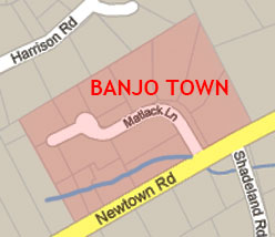
on Newtown Road, Ithan (formerly Radnorville). It sits
approximately ¼-mile west of the historic
Radnor Friends Meeting House and 13 miles NW of Philadelphia. The name has all but disappeared
into folklore since it vanished from official maps
some time after 1948, but its legendary community and
distinctive wood frame houses are still very much in
evidence as a standalone piece of American history.
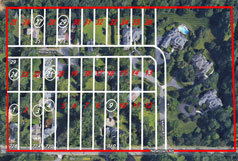
1864 lots overlaid onto Google Maps, showing today's eight surviving wood frame houses on the original Matlack Tract [click to view]
Click to view in Google Maps
Newtown Road decree, 1724 [click to view].
Original doc: Chester County Archives.
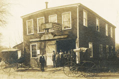
Radnorville Village Blacksmith c.1890,
now 605 Conestoga Rd [click to view]
photo RHS, restored 2022
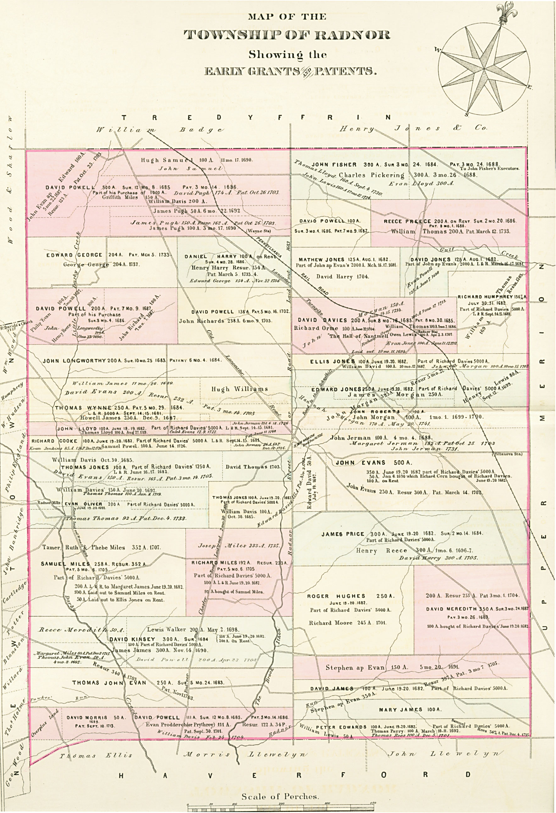
Around 1663 40,000 acres of Pennsylvania were settled predominantly by members of the Society of Friends (Quakers) from Radnorshire,
Wales. Until then it had been almost exclusively populated by Lenni Lenape Indians, but with the newcomers' arrival it became known as The Welsh Tract.
Banjo Town, established 200 years later, is a 12-acre section of the initial land grant made to Richard Davies
(aka Daves) when in 1681 he bought 5,000 acres from William Penn, who had been granted the land by Charles II of England. Radnor Township was founded a year
later. There is no record of Davies ever visiting America and he soon sold his land, mostly in the southern part of Radnor, to various purchasers. 350 acres were sold to John Evans and then in 1688 (20 years after William Penn had been imprisoned
in the Tower of London for blasphemy) 152 acres were conveyed
to John Jarman (aka Jerman), constable of Radnor Twp
1685-1721. This included 26 acres split between
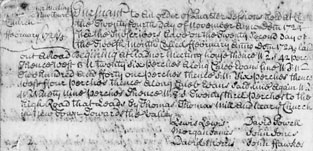
the north and south sides of the lane that was to be called Newtown Rd. Newtown itself was established in 1681, being William Penn’s first planned inland township west of Philadelphia. Newtown Rd started out as an informal route, and so was already referred to by that name from c.1685. It wasn't “laid out" until 1724 [see left], though it was still a dirt road even then. What they actually described as laid out meant they cut the trees low enough to clear a path and allow the high axles of wagons to pass over them. Neither the tree stumps nor rocks were removed. The earliest countryside roads went between farm (or mill), market and church. The name Newtown Rd didn't appear on maps until the latter part of the 19th century. Until then it was known simply as "the road to Newtown" or "the road to Ithan", depending on one's direction of travel.
Radnorville was originally the center of activity in Radnor Township. All major routes of travel intersected the village. East and west ran Old Lancaster Rd, the main highway for settlers going west and beyond. North and south ran Radnor Chester Rd, laid out in 1681, connecting the Schuylkill River with Chester on the Delaware River. Sproul Rd was not built until the mid-20th c. and until that time Radnor Chester Rd, which now dead ends at Newtown Rd, continued straight through the Atterbury Estate. Newtown Rd began in the center of Radnorville and ran westward to Darby Paoli Rd, which was laid out in 1694.
Radnorville had several frame and stone buildings, the most noteworthy being the Ithan General Store, Radnor School #2 [see right] in the triangle opposite Radnor Meeting, and the Blacksmith & WheelwrightShop [see left]. The original Ithan General Store was where one of Jarman's sons was born – Radnor Township's
very first registered birth – and was used as the place
of worship for Radnor Friends before their own temporary log Meeting
House was built around 1695 across the road, followed by their more permanent stone building in 1717-18. Part of the General Store later
became the Ithan Post Office, serving a population of 300 when its application was approved in 1888. Although about the same distance from Wayne, and even nearer to Ithan, the postal
address of Banjo Town nowadays is Villanova - formerly Villa Nova, named after the Spanish order of Augustinians inspired
by Santo Tomás
de Villanueva.
By 1894 Radnorville was also colloquially referred to as Cornog's Corner after the owners of the general store. According to that year's Historical Cyclopedia of Delaware County: "Radnorville contained a store, hall, hotel and postoffice, named Ithan. The village has six unnamed streets and about 30 houses." As well as houses opposite Radnor Meeting this would have included the first nine houses of Banjo Town, and several houses in a similar development started two years later on Radnor Avenue.
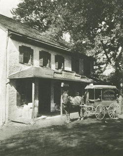
Cornog's Corner (Ithan General Store), 1910.
Now 601 Conestoga Rd
[click to view]
photo: Radnor Historical Society,
restored by Phil Graham, 2022
Radnor School #2, built 1856.
Now 600 Newtown Rd
[click to view]
photo restored 2022
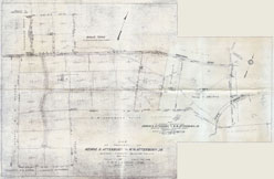
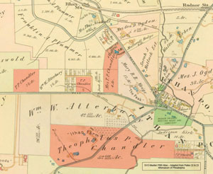
The speculative Atterbury plan, 1848-9
[click to view]
Radnorville's
name changed to Ithan on maps between 1902 & 1908 because of its
similarity to the nearby town & PRR station both named Radnor (formerly Morgan's Corner). It was altered
to match the name of the adjacent Ithan Creek, itself named from the mid-Wales River Ithon (Afon leithon in Welsh). The
Kings Highway, a dirt road, had been laid through Jarman's property in 1691
(called Lancaster Rd from 1733, later Old Lancaster Rd, and now Conestoga Rd). Legend has it
that Jarman was so opposed to the road that he initially continued to plant crops across it in defiance.
Title to the land changed
hands several times over the years. In 1864, on her widowed
mother's death, Sarah Jane Matlack, née Siter, (widow
of Isaiah Matlack M.D.) was allocated 56 acres including
the present land of Banjo Town 43 years after the death
of her father, John Siter, whose estate was divided between
herself and her sisters Elizabeth S. Parke and Mary Anne
Jacobs. She was from the Siter family who owned and farmed much of the land south of Wayne and built a sawmill in 1799 at the site of what is now the Mill Dam Club[see right]. Her 56 acres extended from the present west
boundary of Banjo Town north-eastward across the intersection of Newtown
and Conestoga Roads where, before the arrival of
the Pennsylvania Railroad, the covered wagons trailed
between Philadelphia and Lancaster. Before that it had
simply been an Indian trail between the Delaware and Susquehanna
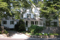
Rivers. By the 1850s over 8,000 of these huge wagons lumbered regularly along this road, bringing food and produce to Philadelphia markets. Matlack's own house still exists today, known as Wayside at 569 Conestoga Rd, and included the barn just to the west. Her African American coachman, Frank Ridgley, also resided there according to the 1900 census, and he became owner of Banjo Town's Lot 31 in 1902, paying $165 to his employer. No house was ever built on his lot.
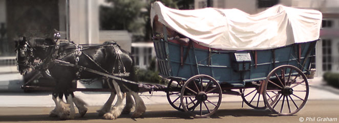
Conestoga Wagons originated in Pennsylvania in the early
1700s & were still in use during Banjo Town's
construction.
Sarah Jane Matlack's parcel included the historic
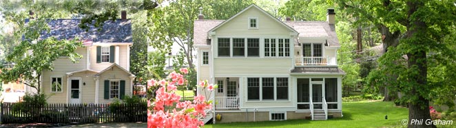
Meigs estate [see lower right] where two family houses were built (The Peak, 1903 & Locust Hill, 1916). She also owned land across Newtown Rd where the young Ellen Mary Hare Cassatt later lived. Ellen was a daughter of JG Cassatt who succeeded his more famous brother, AJ Cassatt, as President of the PRR and owned the estate Kelso, first in Rosemont and later another by the same name in Paoli. She was also a favorite niece of the painter Mary Cassatt, memorialized in many of her paintings, including Ellen Mary Cassatt in a White Coat (1896), and The Pink Sash (1898). Her own daughter, who shared the same name, became Ellen Mary Cassatt Meigs, when she married into the same Meigs family.
The Cassatt land was later acquired by William Wallace Atterbury who, along with his brother, had a speculative plan drawn up for the development of much of the Ithan land they owned. While development did eventually take place this redundant plan only serves to note what might have surrounded Banjo Town, since what we see today on his former land is a less spacious, and presumably more profitable, division [see left].
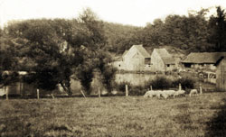
Edwards Mill (formerly Siter's Mill)
– today's Mill Dam Club [click to view]
photo RHS, restored 2022
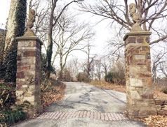
Entrance gateway to The Peak (Meigs estate)
[click to view]
[click to view]
During
the Revolutionary War all the land directly
in the line of sight linking Philadelphia, the lookout post east of Ithan's
Friends Meeting House, and Valley Forge, was designated
a no man’s land. This
eastern outpost was less than a mile west of the original Sorrel
Horse Inn (now part of Agnes Irwin School) which reputedly
housed George Washington during the 1777-8 Valley Forge
encampment. (An inn by the same name appeared later, closer to Radnorville.) Washington's troops were camped approx 300yds south-west of Banjo Town on cleared land now memorialized by the name Camp Woods, while the Friends Meeting House, in what is now Ithan, was annexed as officers' quarters and a hospital. This was in the year of the Paoli Massacre, where 272 of Washington's men were killed, wounded or went missing, and just before the British seized Philadelphia. Others of Washington's US Army were simultaneously encamped several miles to the north-west at Valley Forge.
Radnor suffered from the British during their occupancy of Philadelphia with many families having their livestock, crops and possessions confiscated, leaving them without provisions through the winter of 1777-8. Many skirmishes between British and Americans took place at this time.
Great prosperity came to Radnor after the Revolution with an abundance of saw and grist mills, new settlers, and highways. This included in 1792 America's first toll road, the Philadelphia to Lancaster Turnpike, and in turn many wayside inns. But the Banjo Town area still remained as farmland and
woods for another 100 years.
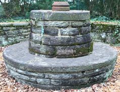
Site of Washington's Camp - The Radnor Picquet, RHS [click to view]
Monument at site of the The Radnor Picquet [click to view]
In 1832 the Pennsylvania Railroad arrived on a westerly route out of Philadelphia directly through St. Augustine's Academy (today's Villanova University), parallel with the Lancaster Turnpike. Known as the Main Line of Public Works of the State of Pennsylvania the railroad connected several existing communities and created many more in its path, giving birth to the name The Main Line. The Railroad was funded by wealthy industrialists to ease their journey into Philadelphia from their summer residences, country estates and gentleman farms. It added much additional prosperity to the area and, in keeping with the owner of the Ardrossan Estate's thoughts much later, led to the need for artisans to live nearby to service those with greater wealth. MORE DETAILS
PRR map, 1874 [RHS] - Click to view.
[Click vid to play]
OTHER RESOURCES:
Link to a complete set of historic Banjo Town DEEDS (transcribed). Link to Banjo Town PROPERTY INVENTORY database. Link to BLUEPRINTS & DRAWINGS of these & other Ardrossan-related properties.
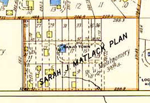
1887 map shows a spring house (red) & the first 3 houses. Of these only Lot
1 survives, plus the barn on Lot 3.
T.P.Chandler & his wife owned land in Banjo Town; plus lots to the W, E and SE, surrounding Atterbury's Farm.
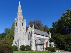
They donated the northernmost part of the eastern lot for a new Chandler designed Christ Church Ithan to replace the old wooden church on Radnor Chester Rd. [photos opposite]
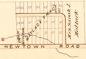
In 1864 a 12-acre plot was divided from the extensive estate of John & Anne Siter, now owned by their three married daughters, Eliza Parke, Mary Ann Jacobs and the widowed Sarah Jane Matlack. The first two sold them to the last, but it was not until 21 years later, Feb. 4, 1885, that Sarah Jane Matlack employed the Berwyn based surveyor John F. Kauffman* to draw up 36 separate lots to the west of the so-called Matlack Tract. He arranged it in three rows of 12 lots running
roughly north/south. Twelve of them faced onto
Newtown Rd while the remaining 24 bordered the dead-end
40-ft. wide private "avenue" which was to become Matlack Lane[see left].
We
can only guess why the 70-year-old Mrs. Matlack, who owned
40 acres in Radnorville, suddenly
decided to split this particular tract. Did
she need money from selling the land? Was there
an increased demand for artisans in the Ithan/Wayne
area or were there already rumors of another railroad
coming by? We may never really know.
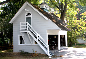
Over the years
the lots were combined and renumbered as they were sold and re-sold, mostly by investors, but before 1900 only 11 structures were built, one of which was a twin, later merged into one house. In the 20th century a stone duplex and two additional wood frame houses were added, one of which was replaced by three large stone mansions in 2002-3. Three of the initial wood frame houses on Matlack Lane burned down some time between 1912-17, but they were rapidly destroyed due to
their frame construction and an inadequate
water supply. Today just eight houses and two original barns from the 19th c. remain.
The boundaries of Banjo Town have always included
the 3.8 acres to the east of Matlack Lane, however there were no permanent buildings
on that tract until the 1961 map.
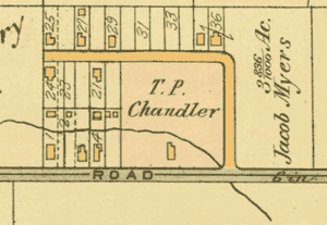
A very similar sized parcel split occurred a short while later ½-mile east on land wholly owned in 1900 by noted architect, housing developer and landowner Theophilus P. Chandler who owned land all around, and within, Banjo Town[see left]. Chandler owned, designed & built his own Ithan Farm and various adjacent properties on the south side of Newtown Rd. He also designed and built Christ Church Ithan on Conestoga Rd, on land he personally donated [see right].
At least three houses on the north side of a street now called Radnor Ave appear to be identical to some of the original Banjo Town houses. It was written in the 1955 Bulletin of the Radnor Historical Society [p.8] that Joseph W. Worrall (aka Worrell), the miller, built these houses in the 1870s and that it was the area's first speculative real estate venture, but we now know Radnor Ave was not laid out until 1887 by John S. Garrigues, and the first map to show houses there was 1892, seven years after the Matlack Tract had already been subdivided by John Kauffman. But it seems reasonable to assume the two developments were built somewhat contemporaneously in the late 1880s because of the identical structures, the timing, and geographical proximity. Other facts contradicting the "first speculative development" claim for Radnor Ave is that we know Garrett Ave was laid out from 1871, and the town of Wayne even earlier, starting in the 1860s.
*In 1888 John F. Kauffman was listed in The Wayne Signal as V.P of the Alpha Choral Society which met on the 3rd floor of the Wayne Opera House and performed in the 2nd floor auditorium.
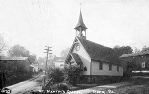
above: postcard of St Martin's Chapel, est.1894, looking S. on Radnor Chester Rd, to Conestoga Rd. junction at Ithan Gen. Store.
[photo: RHS, restored 2022]
below: the Chapel's 1916 replacement, Christ Church Ithan, further E. along Conestoga Rd.
The
1881 Railroad Atlas showed no buildings here but by the 1887 map
there were three permanent houses indicated [left above] on what was then identified as The Matlack Tract -
one on each of Lots 1, 35 and 36. A small wooden barn
by the stream in the center of Lot 3 lasted until c.1948. Its stone foundations still remain about
a foot below ground level, while the larger barn straddling Lots 3 & 4 appeared at the same time as the very first house. Another on Lot 1 remains to this day, probably rebuilt on the same stone foundation.
Deeds indicate that the Railroad Atlases of this era were several years out of date by the time they were published, and in fact the compilers were not surveyors – their drawings merely approximated the location of buildings and lot divisions – so while they are a rough guide the deeds show these maps to be anachronistic. Fortunately as each Banjo Town property was sold words such as "with frame dwelling" were noticeably added in to the deed of sale, giving a much more accurate date for each building's construction. This was then confirmed in most cases by the subsequent map's publication.
The two oldest structures still standing in Banjo Town today were built 1885-6 on Lots 1 & 3 (728 & 724 Newtown Rd), originally owned by George W.
Derrickson and James Herrin respectively. Derrickson was a local auctioneer, who also owned Lots
2-3 until 1886, & 20-21 (22 Matlack Lane) until 1889. Derrickson’s
three southernmost lots were rearranged as two in 1889 when he sold off some of his land.
By 1913 all the original buildings had been completed. In 1889 Whiteman (Lot 3) bought a 20' wide strip of land from Derrickson's Lot 2, thus protecting open land between them. A decade later Whiteman owned part of Lots 2 & 23, plus Lots 3, 22, 21, 20 & 29 in their entirety. Upon his death in 1914 Whiteman's executor Henry Pleasants sold all his land to Col. Robert & Charlotte Hope Montgomery, who had just built Ardrossan and wanted additional off-site staff accommodation.
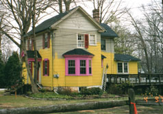
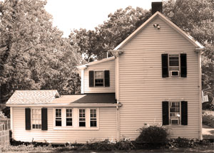
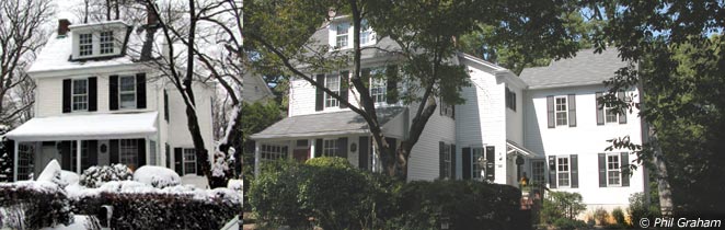
W.side Lot
3 [#724] – original 1885-6 structure on right. Various
extensions were added, demolished & replaced
by 2009.
[also see below center]
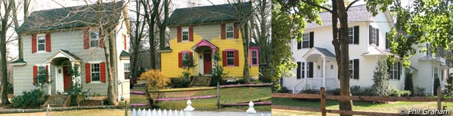
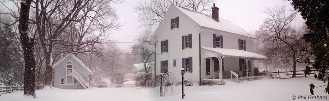
The
original eleven houses of Banjo Town were built of wood
frame on a field stone base, covered with a hard white
pinewood siding. Taking the house at 724 Newtown
Road as an example [left & below], many changes were made
over the years. This house, built 1885-6 by or for James Herrin, like all but one of the others consisted of one front section, had two rooms downstairs, and two bedrooms
upstairs. Chimneys at both ends of the house allowed it to be heated by wood stoves in each of the four
original rooms, one of which was used for cooking. Some houses were built with the front door and staircase in the center, others with them on the left. All of them were built with covered, wooden front
porches. The porch on Lot 3 was demolished after 1949, Lot 1's earlier, and both were replaced with a brick patio similar to those designed for the stone duplex shown in a 1920s blueprint by Louis S. Adams. All the other remaining houses, bar Lot 22, still retain front porches to the original design.
There was no running water inside the house,
it being collected either from a well or Van Lear's Run, the creek that bisected Banjo Town, and the privy was an outhouse at the far end of the garden. At #724 an extension was attached at the rear in the early 1900s
for a separate kitchen, and a third bedroom
added over that. A porch alongside the kitchen to the
rear of the house was added and then enclosed to make a small living
room and, still later, a small room was added to the
rear of that by the second owner, Davis Whiteman. He used it as a cobbler's
shop when he retired from his premises in the Wayne Toll House, primarily run by his wife Mary who had been in the Pike Company's service since 1863. This
briefly became a downstairs full bathroom before the current
remodelling. The kitchen chimney was demolished by
Bertram Wolfson (lawyer, owner 1958-66,
and author of this original article) to make way for
a washing machine.
Rear of Lot 3 [now #724] showing 20th c.
add-ons (left photo) & 21st c. changes (right). Front section remains intact.
Original Lot 4 [now #720] showing original
front structure and early addition (left photo), & much later addition
(right).
By
2008 it was clear that all the leaky, rough,
make-do additions on Lot 3 would either fall down of
their own accord or would have to be replaced - so
they were demolished. A new kitchen and family room has now been built
on approximately the same footprint and a screened porch replaces the cobbler's shop. Similar updates, expansions and improvements
have now been made to all the original Banjo Town properties
still standing, though as most have managed to retain
the original front sections visible from the street
they are largely true to their overall look in
the 19th and early 20th centuries.
In 1988
Radnor Township added the eight original Banjo Town houses that remain to its list of Historic
Resources, along with the central 1918-19
stone duplex, and in 2004 again recommended to “make
sure that important resources such as Banjo Town are included
in the expanded resource inventory being undertaken” as
part of the ongoing Pennsylvania Historical and Museum
Commission Work Program. 20 years later all nine properties are included in the 2,000+ list compiled by Radnor Historical Society, though despite public recommendations for inclusion in a proposedordinance there is still no official historic designation or oversight by any Township authority to review properties outside of three specific areas. Many have suggested a simple review by the Historical & Architectural Review Board (HARB) prior to granting a demolition license would be in the interest of the community.
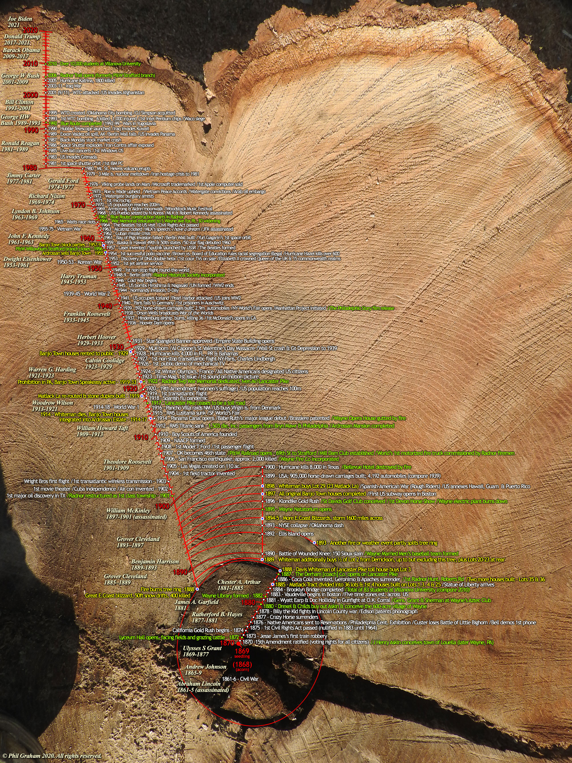
Banjo Town red oak stump
[Click to view timeline 1868-2020]
By
1892 three more houses had been built -
on Lots 4, 25, & 27 [see plan above]. The house at the NW corner (Lot 25) was inhabited
by George Handy, an African-American, and his son.
Mr Handy became one of the trustees of the soon-to-be-built Wayne A.M.E. Church. They had purchased the lot on the corner of W. Wayne & Highland Avenues in 1890 to build the structure that was finally completed in 1893. Handy was a good natured man who did odd jobs
around the neighborhood and collected food waste for his pigs. One night he heard what sounded
like a burglar prowling outside his house. He took
his gun, waited until he heard the sound again, and
fired in its general direction. There followed a
deathly silence and he proudly announced to his wife
that he had shot the burglar but would wait until
daylight to inspect his victim. Next morning Mr Handy
went out to discover what he had shot dead
was simply his own horse. His house on Lot 25 no
longer exists but wind chimes are still to be heard
nearby, no doubt warning away any vengeful equine
spirits!
Lot 24 [#29 Matlack], winter 2011 - both
front doors can still be seen either end of
porch. House first appears on 1897 map. An identically built duplex still stands at 120-122 Radnor Ave.
The remaining frame
dwellings on Lots 9, 21, 24 & 29 on Matlack Lane
were built by 1908. Lot 24 [above] was a similar
design to the others but was built as a duplex. Although
the house was combined by the 1940s two separate
front doors still exist on the front porch to this
day, matching an identical house on Radnor Ave.
In 1948 the name Banjo Town appeared on an official
map for the second time.
Though he never visited, the closest we can imagine porch recreation in Banjo Town might be from this brief clip of former coal miner Roscoe Holcomb (1912-81), a prominent Appalachian musician.
How Banjo Town got its name is a matter of much speculation.
In early days the community was also referred to as Banjo Alley and Banjo Row, but Banjo Town was the name commonly recognized well before 1900. While The Matlack Tract still remained initially on maps, Banjo Town started to appear alongside it from 1937. Those of us here today have heard the old stories handed down through generations telling how residents sat out on their porches strumming a banjo at dusk. (On more than one occasion my wife has woken from a deep sleep to the ghostly vision of an old, tall, white-haired African American folding linen in the corner of one of the original bedrooms. He appears to be moving it out from a location which we now know is a demolished closet, as if to make space for us to unpack!)
African Americans introduced many variations of the banjo from Africa and the Caribbean, and in the 1900s the pejorative term Banjos was routinely used not just to describe Southern plantation musicians but all Black people across North America. Others widely believed that most Black people possessed an innate musicality, at the same time undermining their intelligence. All we know for sure, from photographic evidence, is that every original Banjo Town house was once fronted with a wooden porch, and here residents were said to relax with home-grown music at the end of a hard working day.
Black and White occupants are indicated in the early censuses, and lived and worked alongside each other in Banjo Town. The whole community was racially integrated, and music would have been a uniting force.
As a pastime throughout Penn's Woods, music had long been a tradition. The historian Thomas Allen Glenn wrote in 1896, "Often, especially on Sunday evenings, the Welsh were accustomed to gather at each other's houses to sing and play upon their national instruments, and held periodic music festivals. In the morning, the maidens would go up to the hills to tend the flocks, returning in the evening, singing and playing on their small harps." To imagine any race here strumming banjos in the days before radio and television therefore doesn't seem too much of a stretch, so for now the tales handed down seem to fit.
For historical context, post-Civil War Black Reconstruction was widely viewed as a failed experiment in the late 1800s, and African Americans, many of whom had fled north to the Philadelphia area to escape slavery, were still subject to widespread prejudice. Banjo Town, though small, was more receptive, and by all accounts a fully integrated, progressive community. In 1893 the gifted Black painter Henry Ossawa Tanner, a former PAFA student who studied under Thomas Eakins, returned to the city and painted his most iconic painting, The Banjo Lesson. The image of the Black man playing the banjo had already appeared in paintings and photographs throughout the late 19th century, but Black minstrels had mostly been portrayed as somewhat buffoonish and dim-witted entertainers. What Tanner brought to his canvas was a sense of dignity, intelligence and sensitivity that was refreshing to American culture, and although he didn't personally find the kind of equality here that he experienced while living in Paris, he eventually became our first African American celebrity artist. The Banjo Lesson is now his most widely-known work, and in the 1890s this painting would have reinforced the widely held association between Black people and banjo playing.
There are additional connections to Tanner here. Firstly, Lewis Rodman Wanamaker, son of the department store magnate who was responsible for the continued success and major international growth of the family stores, rented the Ardrossan Estate's Murray House in the 1930s, ¼-mile from Banjo Town (where his Wanamaker Paddock was once situated). He knew Tanner well and personally sponsored the painter's trip to the Middle East in 1897. Both Wanamaker and Tanner had lived in Paris in the 1890s, though we can't be certain if their paths later crossed again in Radnor. While we know Wanamaker would have passed by Banjo Town we can't say whether Tanner ever came so close. What we do know is that The Banjo Lesson, although painted in his home studio in Philadelphia, was from a series of sketches Tanner had made while in the Blue Ridge Mountains of North Carolina in 1889.
In 1893 he also created an illustration, similar to the painting, for Harper's Young People magazine, and this was drawn from a photo study which we could perhaps whimsically imagine being captured on any of our Banjo Town porches.
Secondly, one of the best known photos of Tanner was taken in 1907 by Frederick Gutekunst whose work included many photos of our local area, including a series on Henry Askin's Louella Mansion. Socially it was still a small world in the early 1900s, so today's "six degrees of separation" were more like one or two back then.
Another theory about the origin of Banjo Town is that the name might have described the physical layout of the settlement, being roughly in the shape of the cigar box banjo, popularized at the time of the development by St. Nicholas Children's Magazine, and later The American Boy's Handy Book. Both had published a story and diagrams of how to make a banjo with little more than a few scraps lying around at home, leading to a nationwide cigar box banjo craze. Banjo Town started out as a round-edged rectangle of houses with a turning circle and open grass field near the center where lots remained undeveloped. Matlack Lane did at one time join Newtown Road at both the east and west sides, with the shape being completed by the driveway alongside #728 which once provided direct alternative access to Newtown Rd from Matlack Lane. It is easy to see from the Franklin Survey maps of 1937 & 1948 [above] how Banjo Town might look vaguely like a cigar box banjo. By way of comparison at least one recently demolished cluster of social housing on the South Coast of England is still described by former residents as having "East & West Banjos" in the 1920s. It was arranged similarly to any street named Circle in Radnor today.
The 12-acre plot had originally been marked on maps as The Matlack Tract, after the eponymous landowner, but it wasn't until the 1937 & 1948 maps that they officially recognized the local vernacular, and the name Banjo Town appeared. When the sub-divided lots were acquired by Colonel Montgomery, between 1914-17, he and his architect-in-residence, Louis S. Adams, used the name Banjo Town, but plans and correspondence about the area just as often referred to it as the Little Village. However, as the original name was already too ingrained the alternative suggested by the owners of the grand Ardrossan Estate & Farms never stuck. Instead The Village was later attributed to the plot where the Hopeton Lane cottages were built in 1941-2, and more recently, in 2016, to the new cluster of luxury houses being built on Ivy Lane, between Ardrossan's now-defunct Water Tower and its old estate house, Ivycot. Against all odds Banjo Town has physically survived into the 21st century, but beyond its characteristic stone walled borders it is largely an unfamiliar name to all but those who live nearby. Indeed its existence is probably one of Radnor's best kept secrets!
Early 1900s Ithan & St. Martin's baseball team. [Radnor Historical Society]
The first new owner of Lots 1-3 (now split into separate 724 & 728 Newtown Rd properties) was shown on the 1887 map to be George W. Derrickson, described in the 1880 census as a self-employed "auctioneer". Military records show someone by that name (possibly his father - tbc) as a Company K sergeant (Veteran Reserve Corps 1863, discharged July 6, 1865) who had fought for the President in many fierce Civil War campaigns in Virginia as well as at Gettysburg. Possibly it was his son who later settled in this area and built one of Banjo Town's first dwellings.
In 1890 Edward Whiteman was born at 724
Newtown Rd, then known as Lot 3 and subsequently redesignated
Lot 2 when the lots were combined. As stated above his grandfather was
the cobbler in Wayne whose wife collected
Lancaster Pike tolls, and his father worked
for the PRR. His great grandfather/mother were German immigrants, Casper & Sarah Whiteman, among the first generation of Lancaster Turnpike toll collectors. Like
most young boys in Banjo Town Edward Whiteman attended the
Ithan School at the east end of Newtown Rd (now
a dentistry practice) leaving after the third
grade. After school he helped around the house,
taking care of the ducks, chicken, sheep and
pigs kept in the back yard. The ducks and pigs
swam and wallowed in the mud of Van Leer's
Run. By 1948 a large section of the stream
had been piped underground but originally it
was open with a steep bank. In heavy rainstorms
it still materializes overground on the property
immediately to the west of Banjo Town before
plunging into the terracotta pipework and emerging
as a full-blown stream at the eastern side
of #720. It then continues through #710,
passing under Newtown Rd at the corner of
Matlack Lane, eventually joining Ithan Creek to the east of Sproul Rd.
Earlier the locals tried to fill the creek in by using it as the dumping
ground for their cans and ashes. "Tin Can Alley" was how one early
resident described it. The 1881 and 1902 maps show the name Van Leers
Run, but by 1961 the spelling had been changed to Van Lear’s
Run. The stream was named after Vanleer Eachus who owned a vast tract of land encompassing Banjo Town and Radnor Valley Country Club.
Great numbers of children have always been central to Banjo Town. When they were older the Whiteman and
Miller lads played for the local baseball team, The Ithan
Rovers [see left], whose diamond was adjacent on what's now
Harrison Rd. This was sited on
the open land east of the Slaymaker residence where
a tennis court was initially built and then replaced by #758. The Rovers were one of the teams in the Main
Line League, made up of Narberth, Bryn Mawr, Wayne,
Ithan and Berwyn. Throughout the 1960s & 70s, long after the disbandment of the Ithan Rovers, the fields between houses on Harrison Rd continued to be used for various sports by Banjo Towners, as documented in an entertaining 2017 memoir by former resident Gregory Glading.
Other local characters with no known domicile lived nearby and were
consequently either claimed by or attributed to
the Banjo Town community. Among these were "Shaky Jim" who
cut wood and did odd jobs. For this he received his
board. Another was "Dog John" who never
washed or shaved. He collected garbage in his two-wheeled
cart to feed the pigs and lived in a springhouse with
his four dogs. He only worked enough to eat and preferred
to spend his days playing with his dogs which were
trained to dance, jump, and even smoke pipes.
The people of Banjo Town, until at least 1917, were working class and racially integrated. They
either had a trade or performed odd laboring jobs. George
W. Derrickson, Caucasian owner of Lot 1 (#728), was an auctioneer, Davis
Whiteman, also Caucasian, owner of Lot 3 (#724), was a cobbler, and William Short,
an African American who also owned his lot, did odd carpentry
jobs and ran a horse-powered saw mill. Jim Shield
was a Caucasian bricklayer; George Willis, George Handy (Lot 25)
and Jim Patterson were all African American laborers. Matt Edwards
was a coachman and Frank Douglas an electrician, both
Caucasian. Some owned their houses while others rented at rates varying from $8 to $12 per month.
Around 1900 much
of the open land around Banjo Town was purchased, consolidated and large estates constructed.
William W. Atterbury and his brother George owned 42 acres on the south side
of Newtown Rd, running west from Radnor Friends Meeting
House to today's Atterbury Rd.
Atterbury had succeeded Cassatt as President of the PRR and purchased Cassatt's land when he took over the
role.
In 1909-1910 Col.
Robert Leaming Montgomery, founder of the present day brokerage Janney Montgomery Scott, purchased the land from Tryon
R. Lewis at the far southwest corner of Newtown Rd
and Darby Paoli Rd. He is said to have been hunting in the area and when he fell off his horse decided it was the perfect spot to put down roots. In 1911 he completed the construction
of the large 50-room Horace Trumbauer designed Ardrossan mansion, named after his ancestral Scottish village
and centerpiece of what expanded to an 800-acre estate and farm. By 1940 it had become, along with its occupants,
the inspiration for Philip Barry's Broadway play and subsequent film The Philadelphia Story (starring Katherine Hepburn, Cary Grant & James Stewart). The story was later adapted for the Hollywood musical production High Society (starring Frank Sinatra, Bing Crosby & Grace Kelly). As lifelong friends of the Scott family Barry is said to have based his story, and particularly Tracy Lord, the character played by Katherine Hepburn, on the Colonel's daughter, Hope Montgomery Scott. More about that can be found here.
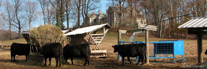
Ardrossan mansion, with distinctive black angus cattle, 2012
If one can conversely
visualize Banjo Town at that time as a mixed community,
with ducks, pigs and chickens running around, several
families living together in some of the houses, and tin
cans and bottles dumped in the backyard to fill the creek,
it is no wonder that Col. Montgomery and William Atterbury
thought that Banjo Town was, or might become, a shanty
town. They were not about to spend hoards of money building
big mansions only to have to drive by this shabby area
in order to get to their palatial estates, so Montgomery and
Atterbury conspired together to purchase the whole area and improve its appearance. Atterbury
was to be in charge of buying the houses, but by all accounts
he believed in the "bull in the china shop" approach and largely failed. He managed to buy just one house while
antagonizing all the other owners so that no one else
would sell to him. Montgomery then personally took charge
of the bulk of the venture, was much more subtle in
his methods, including the use of strangers who acted
as straw parties, and thereby succeeded in buying up the majority of Banjo Town between 1914 and 1917. The Colonel finally bought Atterbury's sole acquisition from the latter's estate after his death in 1939.
The relationship of Montgomery and the tenants of Banjo Town was a patriarchal one, reminiscent
of the feudal relationship between the Lord of the Manor
and tenant. Montgomery had a great affinity with the neighborhood.
He fixed up the dwellings and used them to house
the employees of Ardrossan Estate & Farms. He was interested in the tenants and visited them regularly,
frequently bringing gifts of dairy products. He felt motivated to preserve the feeling of the
community by upgrading the houses. A wonderful memoir of life here in the 1920s by Isabel Jenkin Mahoney can be read HERE.
Of course there was an ulterior motive in the upgrades. The National Prohibition Act hit the social classes hard between 1920-33, though as the federal government did little to enforce it Montgomery set up his very own speakeasy, complete with full bar, in the vast upstairs room of the barn at 29 Matlack Lane. It's not known for sure who its patrons were but word has it that it was a bolt hole for Montgomery himself as much as for Banjo Towners. The same bar counter remained in situ until 2012 when the entire property was largely emptied for its sale. As the last, largely unmodernized house in Banjo Town it stood as a historic reminder of the way things were and the rickety old speakeasy has now become a beautifully renovated private office space.
His improvements,
both structurally and aesthetically, were a luxury that
the buildings had never known. For example in 724 Newtown
Rd he addeded paneled cupboards, bookcases and dentil molding. The carpentry was done by Thomas Mayhem Pinckney (1857-1952), whom the Colonel had employed at his Mansfield Plantation house in S. Carolina. Pinckney, a celebrated African American craftsman now recognized as one of the most prized artisans of his day, was brought up from Charleston to work on Montgomery's Hopeland (Church Rd /Abrahams Lane) as well as his Banjo Town houses. If an emergency repair was necessary
the tenant would call directly upon Montgomery and frequently
he would arrive along with his workmen so he could supervise
the job.
A couple
of additional small barns or stables were built for the horses, and a
stone duplex tenant house was built near the center of
Banjo Town, with the original lane now being shortened and diverted
through Lots 13-19 to accommodate
the new stone duplex. This structure was built identical to three other tenant
houses he had constructed contemporaneously; two further west on
Newtown Rd, and another on Godfrey Rd. All four of these duplexes
remain, now refurbished for 21st c. living but still fundamentally true to the original Louis S. Adams design.
Around 1929 Montgomery
decided to move the personnel who worked on Ardrossan
closer to the farms and thereby earn some income
from Banjo Town. He wanted to create a community for young people at a rental they could afford.
The property was transferred jointly to the Girard Trust
Corn Exchange Bank and himself as trustees.
He made a careful study
and decided that the rent should never be more than $75
per month per house. By his reckoning there were a great
number of people who would be willing to pay that amount. If a tenant wanted certain repairs or improvements
his rental was increased proportionately but in no case
would it exceed $75 per month.
At that time the procedure
was for a prospective tenant first to make application
to the Girard Trust. If passed by them the applicant
was then granted an appointment with Col. Montgomery
for the second phase of the examination. He asked each
applicant two questions: – 1. Are you a Democrat or a Republican?
– 2. Are you Wet or Dry (i.e. do you drink alcohol)?
This was during the time of Prohibition. In accordance with Montgomery’s
politics the applicant was only granted a lease if he declared
himself to be a Wet Republican!
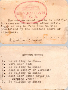
1950s membership card
The notorious Banjotown 'speakeasy' night club where the upstairs bar counter,
though upturned, still remained until 2012 - dating back to the dry days of Prohibition.
First appears on 1900 map.
Banjo Town during the 1930s and 1940s was a remarkably close-knit community.
Everyone was a friend of everyone else. When a vacancy
occurred another friend was notified and the vacancy
quickly filled. It was given that all personal tools,
machinery and facilities were to be willingly shared
across the community. At least one resident still carries
his own fanciful, self-made Banjo Town community membership
card declaring that to be the accepted code of conduct [see original left; new version right]. This warm relationship and strong group spirit gave rise
to many interesting activities over the years. On the
second floor of the stable still on Lot 23-24 (29 Matlack
Lane) the tenants got together and initiated the Banjo Town
Night Club (formerly Montgomery's speakeasy), serving up drinks and entertainment for the
whole community on warm summer evenings. In the 1940s
art shows were held and it was also used by children for the performance of plays.
Between
1941-49 the McAusland family were tenants on Lot 24.
I caught up with Randy McAusland in 2012 (then hosting as DJ Randy
Neal on wobofm.com in Cincinnati) whose parents, John & Helen,
raised him in Banjo Town with his sister Linda and brother Neal.
"The
happiest, most free-spirited times of my life were in
Banjo Town," he says, "biking to the post office/grocery
and gas station at the end of Newtown Rd, roaming and
exploring the Montgomery Estate, riding the old P&W
Trolley to 69th St and then going into Philadelphia."
He babysat at the former Slaymaker house at the back on Harrison
Rd where he "spent
hours reading Poe and playing a card game named Authors. On
the western edge of Banjo Town was a wartime Victory Garden. "It was about half an acre just the other side of our post and rail fence",
he recalls – land now part of 22 Matlack Lane at the back of the speakeasy. "Col. Montgomery would prep the land with plough
and harrow and leave the tenants to continue. Everyone started seeds, hoed
and weeded. All the kids pitched in. We grew peas, spinach and lettuce in the early season followed by pole,
wax and bush beans, corn, squash, onions, beets, carrots plus cherry and other
varieties of tomato. George Munger dug and kept his own garden to the north-west
of his house and fenced it against rabbits." Munger's garden was on vacant land now occupied by a new mansion on Harrison
Rd. "Heavy duty canning took place during
harvest seasons in Mason jars. The Colonel expanded the gardens around
Ardrossan and shared the bounty with everyone who helped."
The 1949
plan drawn up by
local surveyors M.R. & J.B.
Yerkes shows Banjo Town now consolidated into just 11
lots in various shapes and sizes with the remaining
4.6 acres north and east of Matlack Lane being
wholly owned by George
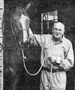
Munger. Munger
was a celebrated athlete, football coach and
later director of physical education at University
of Pennsylvania from 1938-74.
From 1947 Munger lived on Lot 27. Then in 1950 he built a house
and barn on a separate parcel in the NE of
Banjo Town. He constructed the barn across the same two lots where houses had burned [see Banjo Town Evolution & Development vid above]. In the 1950s Munger would regularly lead his horses between the gardens west of Banjo Town across Abrahams
Lane into Ardrossan where he exercised them around Orchard Lodge, Hope Scott's own stables and pastures. Subsequently in 2000 his house and barn were demolished and the land subdivided. Four large, similar
stone mansions were built there by a local developer in 2002-3.
The core Banjo Town hamlet has so far been preserved with current owners continuing
to improve and restore the old frame houses
while retaining as much of their historical
integrity as possible. Containing some of the oldest buildings
in Radnor Township it is without doubt an area
of historical significance and is recognized by
many as such. Its quirky history is a matter of
great pride to the area and is often
referenced in nearby real estate listings.
In 1955 the Montgomery Estate decided to
sell the houses in Banjo Town and for the first time in
almost half a century all the houses were put back into individual
ownership.
Membership card, updated 2015.
[click to view]
George Munger with 'Bull Cactus', 1983
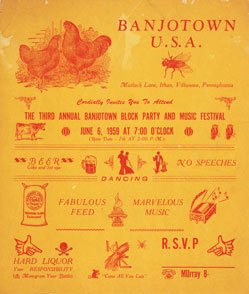
1959 - 8.5" x 10" invitation [click to enlarge]
A Banjo Town block party and music festival was held early summer each year from 1957-1959
when the 10 families in residence combined resources.
The cul-de-sac of Matlack Lane was closed off and decorated
in a circus-like atmosphere. Each household was allowed to invite up to 25 guests. The wives arranged among themselves
to bake and cook for some 250 guests and the whole community danced and revelled in the
Lane as the band played through to the early hours
of the morning.
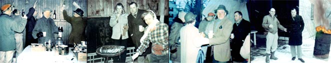
The parties continued in the 1960s, and when the speakeasy became too small for the increase in numbers they were moved to the old 1880s barn (now garages) behind
720-724 Newtown Rd. We can see from the photos it was a chilly winter barbecue with snow on the ground. An old oil drum was set alight, where it burned throughout the festivities.
At some point residents painted their surnames at waist height along the entire length of the walls and while they've now been painted over the names Moore, Munger, Lamason & Kennedy can still be made out in these and other surviving photos.
A 1960s winter snow block party: 2nd photo from left shows Olga & Owen Walsh, Sr. at rear, and far right photo Carmen DiGiovanni (left) with Owen Walsh again next to the flaming oildrum. Others still to be identified. [Photos: Tex Lamason]
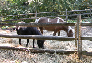
Ponies were a constant and popular feature of Banjo Town until about 2009. A vacant paddock now remains.
728 Newtown Rd extended by Christmas 2012
These days
the occupants are the owners of each house, while a
central barn now straddles three properties (Lots 3,
4 and 21 - now enclosed and used by each as garages),
with a paddock containing ponies (until 2009) to one side. Although Banjo Town was no longer zoned
for livestock by Radnor Township, the owners insisted the ponies were pets, so after surveying
the opinions of other occupants, all of whom were like-minded, they
permitted them to remain. Insurance rates have since
precluded the practicality of keeping horses in a bustling residential area, not least because they frequently
escaped. On many occasions horses were retrieved from surrounding farmland after they apparently conspired to unlock themselves and wander off to the greener pastures of Ardrossan.
A huge ruckus
blew up in 2002 when the most central property of
Banjo Town, 22 Matlack Lane, was put up for sale. It continued
for several months between the seller and surrounding neighbors
when it looked likely a developer was going to buy it and
demolish the old 1,600 sq ft house to replace it with something
around 5,000 sq ft, unsympathetic to the historical look.
A hearing was granted by Radnor Planning Commission who
decided as a whole to defend one of the oldest towns
in the neighborhood and made the following recommendation: "It
is the sense of the Planning Commission that the properties
of Banjo Town, which have a distinctive character in
our Township, be retained and to the extent that applicants
come before Township Boards to seek permission to do
things which are out of character that that Board or
Commission bear in mind what a treasure we have in
that little area." As a result the sale fell through
and the owner showed their spite by randomly painting
the house's features in bright pink and yellow, along with all the
surrounding trees and fence rails; some with pink polka
dots which, though faded still show to this day. When
the house was finally sold it was restored more tastefully
and in total keeping with the area, much to the relief
of its neighbors.
22 Matlack Lane:
Before, During and After the 2003 dispute
710 Newtown Rd refurbished by 2005
22 Matlack Lane - west facade during dispute
Neighbors Tex & Nancy Lamason were among those campaigning for preservation and targeted by the disgruntled owner
22 Matlack Lane - west facade after 2003 renovation; note pink paint residue still on trees!
East facade after renovation
NowadaysBanjo Town is home to a small group of lawyers, salesmen,
brokers, educators, musicians, artisans and their
families who cherish the heritage of their community
and do their best to preserve the unique homes and
remaining open spaces they share. If you pass by and
hear the strings of a banjo above the thump of your
car stereo it might not be your imagination!
This
history has been adapted by Phil Graham from Banjo Town,
Radnor – A Fact or a Legend? Originally
researched and written by Bertram Wolfson, a former
resident of Banjo Town, for his lecture to members of the Radnor Historical
Society (RHS) in March 1963. Subsequently it has been updated with supplementary information from RHS, Ashmead's
History of Delaware County, early atlases of the Main Line, original Delaware & Chester County deeds, and interviews with
early inhabitants, including Edward Whiteman of Ithan (grandson of Davis
Whiteman, the cobbler), Harry Miller of Wayne, Tex Lamason of Bryn Mawr, Randy McAusland of Cincinnati, Mary Shoemaker Bleecker of West Chester, Gregory Glading of Florida, and Diane & Jill DiGiovanni of Wayne.
All photos optimized & restored by Phil Graham, except where credited otherwise.
This is an ongoing
history – if
you have any corrections, additional historical information,
photos, memories or anecdotes please email HERE.
Phil Graham is a graphic designer, historical researcher & former Board Director of Radnor Historical Society, 2012-19. Annie Graham is a professional portrait painter & teacher at Wayne Art Center.

 During
the Revolutionary War all the land directly
in the line of sight linking Philadelphia, the lookout post east of Ithan's
Friends Meeting House, and Valley Forge, was designated
a no man’s land. This
eastern outpost was less than a mile west of the original Sorrel
Horse Inn (now part of Agnes Irwin School) which reputedly
housed George Washington during the 1777-8 Valley Forge
encampment. (An inn by the same name appeared later, closer to Radnorville.) Washington's troops were camped approx 300yds south-west of Banjo Town on cleared land now memorialized by the name Camp Woods, while the Friends Meeting House, in what is now Ithan, was annexed as officers' quarters and a hospital. This was in the year of the Paoli Massacre, where 272 of Washington's men were killed, wounded or went missing, and just before the British seized Philadelphia. Others of Washington's US Army were simultaneously encamped several miles to the north-west at Valley Forge.
During
the Revolutionary War all the land directly
in the line of sight linking Philadelphia, the lookout post east of Ithan's
Friends Meeting House, and Valley Forge, was designated
a no man’s land. This
eastern outpost was less than a mile west of the original Sorrel
Horse Inn (now part of Agnes Irwin School) which reputedly
housed George Washington during the 1777-8 Valley Forge
encampment. (An inn by the same name appeared later, closer to Radnorville.) Washington's troops were camped approx 300yds south-west of Banjo Town on cleared land now memorialized by the name Camp Woods, while the Friends Meeting House, in what is now Ithan, was annexed as officers' quarters and a hospital. This was in the year of the Paoli Massacre, where 272 of Washington's men were killed, wounded or went missing, and just before the British seized Philadelphia. Others of Washington's US Army were simultaneously encamped several miles to the north-west at Valley Forge.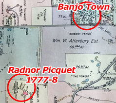
 In 1832 the Pennsylvania Railroad arrived on a westerly route out of Philadelphia directly through St. Augustine's Academy (today's Villanova University), parallel with the Lancaster Turnpike. Known as the Main Line of Public Works of the State of Pennsylvania the railroad connected several existing communities and created many more in its path, giving birth to the name The Main Line. The Railroad was funded by wealthy industrialists to ease their journey into Philadelphia from their summer residences, country estates and gentleman farms. It added much additional prosperity to the area and, in keeping with the owner of the Ardrossan Estate's thoughts much later, led to the need for artisans to live nearby to service those with greater wealth.
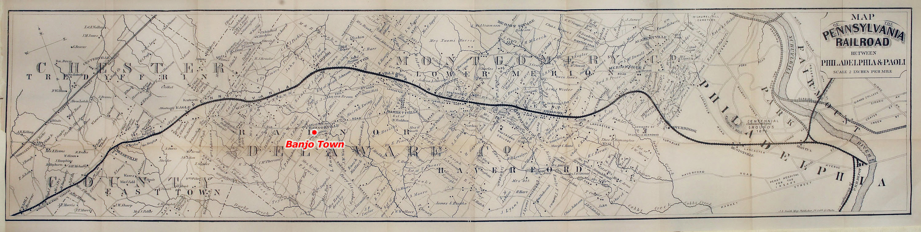

 How Banjo Town got its name is a matter of much speculation.
In early days the community was also referred to as Banjo Alley and Banjo Row, but Banjo Town was the name commonly recognized well before 1900. While The Matlack Tract still remained initially on maps, Banjo Town started to appear alongside it from 1937. Those of us here today have heard the old stories handed down through generations telling how residents sat out on their porches strumming a banjo at dusk. (On more than one occasion my wife has woken from a deep sleep to the ghostly vision of an old, tall, white-haired African American folding linen in the corner of one of the original bedrooms. He appears to be moving it out from a location which we now know is a demolished closet, as if to make space for us to unpack!)
How Banjo Town got its name is a matter of much speculation.
In early days the community was also referred to as Banjo Alley and Banjo Row, but Banjo Town was the name commonly recognized well before 1900. While The Matlack Tract still remained initially on maps, Banjo Town started to appear alongside it from 1937. Those of us here today have heard the old stories handed down through generations telling how residents sat out on their porches strumming a banjo at dusk. (On more than one occasion my wife has woken from a deep sleep to the ghostly vision of an old, tall, white-haired African American folding linen in the corner of one of the original bedrooms. He appears to be moving it out from a location which we now know is a demolished closet, as if to make space for us to unpack!) 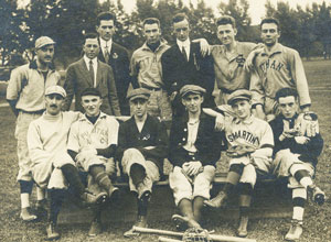


 Banjo Town during the 1930s and 1940s was a remarkably close-knit community.
Everyone was a friend of everyone else. When a vacancy
occurred another friend was notified and the vacancy
quickly filled. It was given that all personal tools,
machinery and facilities were to be willingly shared
across the community. At least one resident still carries
his own fanciful, self-made Banjo Town community membership
card declaring that to be the accepted code of conduct [see original left; new version right]. This warm relationship and strong group spirit gave rise
to many interesting activities over the years. On the
second floor of the stable still on Lot 23-24 (29 Matlack
Lane) the tenants got together and initiated the Banjo Town
Night Club (formerly Montgomery's speakeasy), serving up drinks and entertainment for the
whole community on warm summer evenings. In the 1940s
art shows were held and it was also used by children for the performance of plays.
Banjo Town during the 1930s and 1940s was a remarkably close-knit community.
Everyone was a friend of everyone else. When a vacancy
occurred another friend was notified and the vacancy
quickly filled. It was given that all personal tools,
machinery and facilities were to be willingly shared
across the community. At least one resident still carries
his own fanciful, self-made Banjo Town community membership
card declaring that to be the accepted code of conduct [see original left; new version right]. This warm relationship and strong group spirit gave rise
to many interesting activities over the years. On the
second floor of the stable still on Lot 23-24 (29 Matlack
Lane) the tenants got together and initiated the Banjo Town
Night Club (formerly Montgomery's speakeasy), serving up drinks and entertainment for the
whole community on warm summer evenings. In the 1940s
art shows were held and it was also used by children for the performance of plays.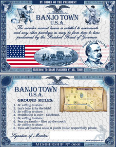
 A Banjo Town block party and music festival was held early summer each year from 1957-1959
when the 10 families in residence combined resources.
The cul-de-sac of Matlack Lane was closed off and decorated
in a circus-like atmosphere. Each household was allowed to invite up to 25 guests. The wives arranged among themselves
to bake and cook for some 250 guests and the whole community danced and revelled in the
Lane as the band played through to the early hours
of the morning.
A Banjo Town block party and music festival was held early summer each year from 1957-1959
when the 10 families in residence combined resources.
The cul-de-sac of Matlack Lane was closed off and decorated
in a circus-like atmosphere. Each household was allowed to invite up to 25 guests. The wives arranged among themselves
to bake and cook for some 250 guests and the whole community danced and revelled in the
Lane as the band played through to the early hours
of the morning.
 These days
the occupants are the owners of each house, while a
central barn now straddles three properties (Lots 3,
4 and 21 - now enclosed and used by each as garages),
with a paddock containing ponies (until 2009) to one side. Although Banjo Town was no longer zoned
for livestock by Radnor Township, the owners insisted the ponies were pets, so after surveying
the opinions of other occupants, all of whom were like-minded, they
permitted them to remain. Insurance rates have since
precluded the practicality of keeping horses in a bustling residential area, not least because they frequently
escaped. On many occasions horses were retrieved from surrounding farmland after they apparently conspired to unlock themselves and wander off to the greener pastures of Ardrossan.
These days
the occupants are the owners of each house, while a
central barn now straddles three properties (Lots 3,
4 and 21 - now enclosed and used by each as garages),
with a paddock containing ponies (until 2009) to one side. Although Banjo Town was no longer zoned
for livestock by Radnor Township, the owners insisted the ponies were pets, so after surveying
the opinions of other occupants, all of whom were like-minded, they
permitted them to remain. Insurance rates have since
precluded the practicality of keeping horses in a bustling residential area, not least because they frequently
escaped. On many occasions horses were retrieved from surrounding farmland after they apparently conspired to unlock themselves and wander off to the greener pastures of Ardrossan.